
Subdivisions and Lot Splits
What is a Subdivision?
A subdivision is the process by which a tract of land is divided into smaller lots for individual sale, usually for the purpose of constructing new residential or commercial development.
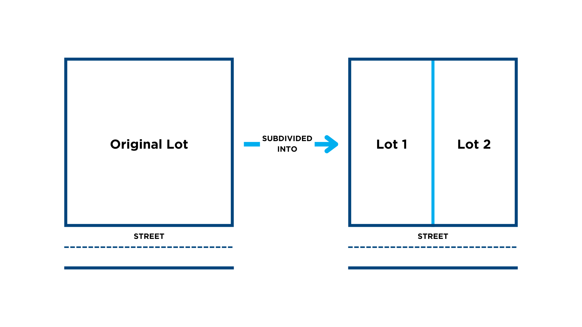
All newly created lots must have frontage on a public street and meet the requirements of the Zoning Code (minimum lot size, setbacks) and the Subdivision Regulations (lot design, location of utilities).
Zoning Code Zoning Map Subdivision Regulations
Apply for a Subdivision
As of January 13, 2025, all subdivision applications must submitted and paid for online using the CAGIS ezTrak Portal. Visit our "Apply & Pay Online" page for more information.
All subdivision applications must begin with a consultation meeting, applied for through ezTrak. For a smooth process, please be prepared to submit a site plan or plat that shows all setbacks for existing and proposed buildings. If an existing or proposed building is less than 5 feet from a proposed lot line, please indicate any openings on the building face.
How to Submit Subdivision Applications on ezTrak
After the subdivision consultation is complete, the application for either a Minor or Major Subdivision will be made available on ezTrak. A complete application contains the following:
-
Current Deed;
-
Legal Descriptions of the property/properties prepared by a licensed surveyor;
-
A plat prepared by a licensed surveyor; and
-
Full payment based on the type of application:
-
Minor Subdivision: $150 per deed stamped. If all properties are to go to the same entity, up to three (3) legal descriptions are permitted for one deed.
-
Major Subdivision: $500 per lot created.
-
Types of Subdivisions and Process:
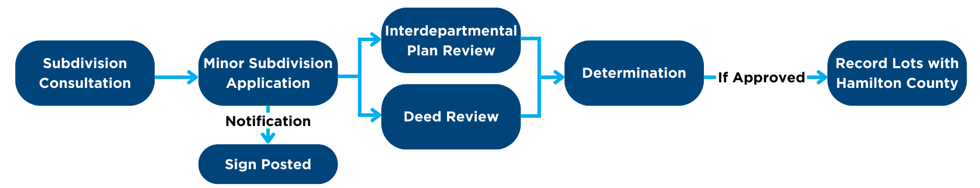
Minor Subdivision
A Minor Subdivision involves only an administrative review, and is not required to go before the City Planning Commission for approval. The process is outlined in the chart below.
Major Subdivision
A Major Subdivision requires a Coordinated Site Review at either the Development or Technical review level, as well as a public hearing before the City Planning Commission for approval. A Major Subdivision consists of a Development Plan and Final Plat. A subdivision will be considered Major if it includes any of the following features:
-
Proposal to create four or more lots;
-
Involves the opening, widening, extension, or improvement of a street;
-
Involves the installation, extension, or modification or a public utility service line, excluding tap connections to existing utility service lines;
-
Involves a parcel of land that the owner or applicant intends to further subdivide and the planned subdivision together will result in four or more lots;
-
Seeks a variance or other relief from the City’s subdivision requirements or the Cincinnati Zoning Code;
-
Includes one or more rear lots, as described in Section 800-03(c) of the Subdivision Regulations;
-
Includes one or more air lots;
-
Involves property within a Hillside Overlay District; or
-
Involves property located in a special flood hazard area, as designated by the Federal Emergency Management Agency.
The process for a Major Subdivision is outlined in the chart below.

Subdivision Improvement Plan
If public infrastructure modifications are proposed as part of a subdivsion application, a Subdivision Improvement Plan (SIP) may also be required. The SIP shows the proposed subdivision with all proposed public improvements to be installed, including water lines, sewer lines, public streets, etc. This drawing is not recorded but provides a plan for adequate access and utilities to all newly created lots, and requires approval from all City reviewing agencies (GCWW, MSD, DOTE, City Planning, etc.) and a public hearing before the City Planning Commission. An SIP is required for new subdivisions that create new streets or require additional utilities. The SIP is not able to be reviewed by the City Planning Commission for approval until it is authorized to proceed by all City reviewing agencies first.
The process for a Major Subdivision with an SIP outlined in the chart below.
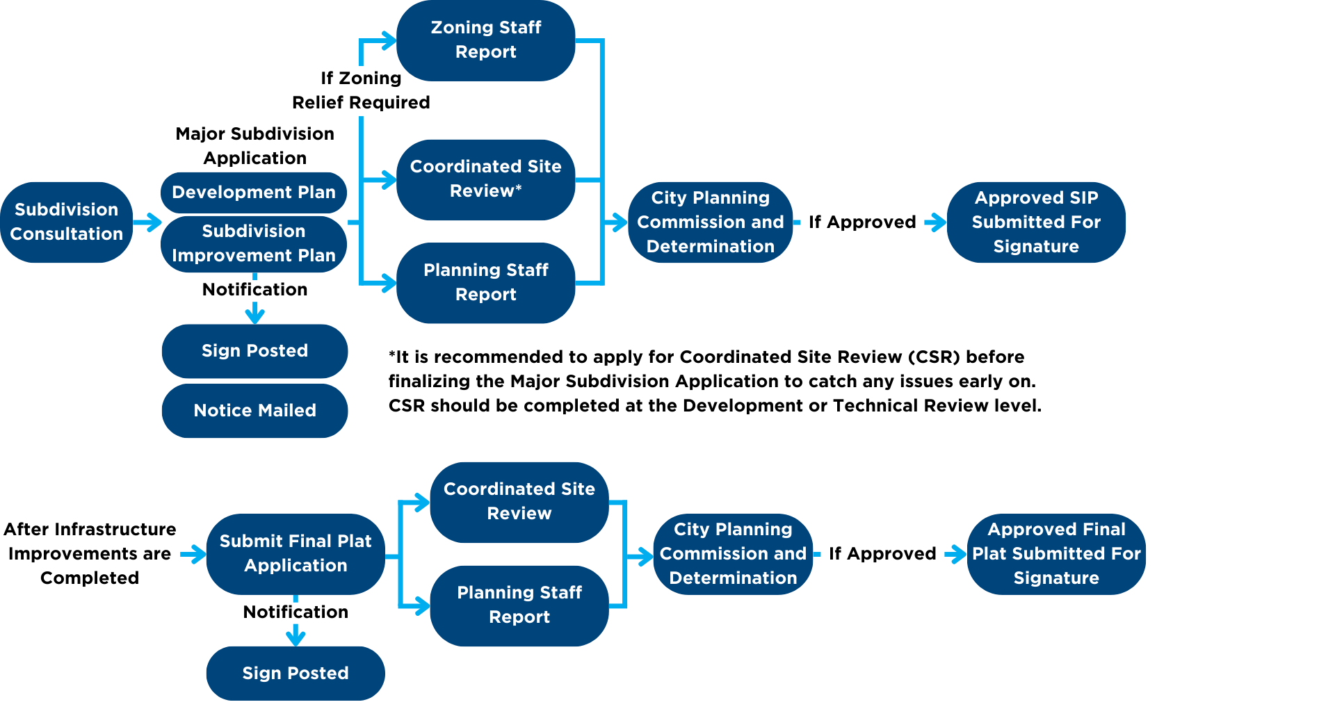
Final Plat
A Final Plat is a drawing showing the division of any tract of land into two or more parcels and prepared for the purpose of recording. This process is part of the Major Subdivision process. Final Plats require approval from all reviewing agencies (GCWW, MSD, DOTE, City Planning & Engagement, etc.) and the City Planning Commission. The Final Plat will not be taken to the City Planning Commission if it is not approved by all reviewing agencies first.