BLINK 2019: Traffic and Parking Information for Return of Art and Light Event
Sep 30, 2019
Traffic and Parking Details for BLINK® Event, Parade
Attendees encouraged to use public transit, carpool
CINCINNATI – Several traffic restrictions will be in place during evenings from Oct. 10 through Oct. 13 so Downtown Cincinnati streets can come alive for the return of BLINK®, an internationally celebrated art and light spectacular.
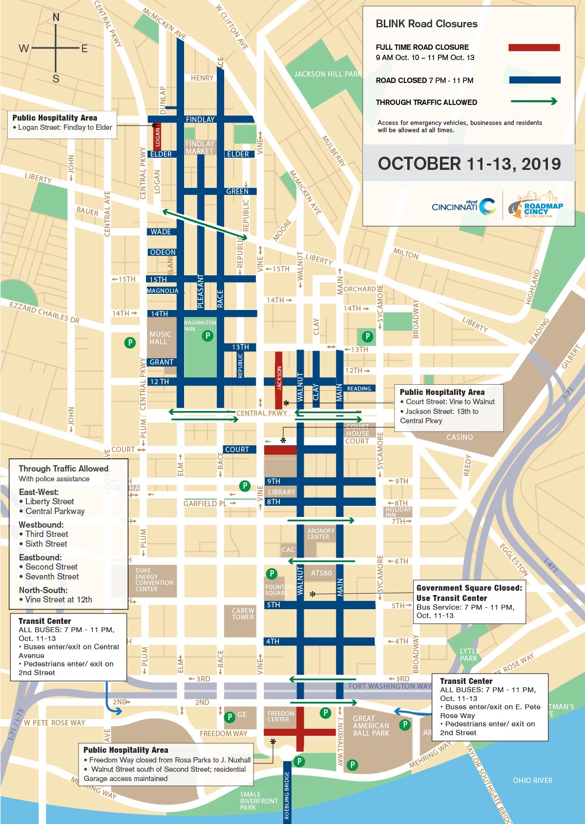
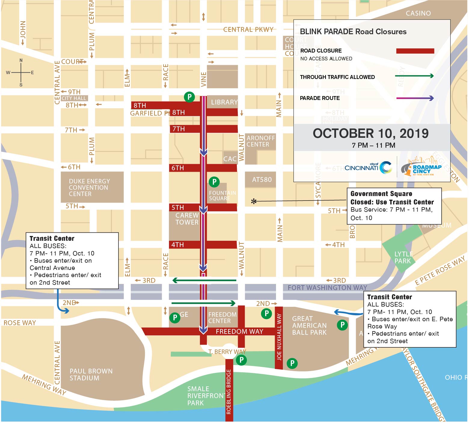
- MAPS: BLINK PARADE | BLINK EVENT | COVINGTON TRAFFIC INFO
More than 1 million people are expected to take part in the art, light and culture event, which will span 30 total city blocks from Findlay Market across the Roebling Bridge and into Covington, Kentucky. In order to accommodate the scale and specific route of the event, the City of Cincinnati, in conjunction with local law enforcement and the Cincinnati USA Regional Chamber, established a temporary traffic pattern plan to support the anticipated influx of visitors and the safety of pedestrians.
The plan includes limiting access to several primary and side streets in the urban core starting at 7 p.m. during each night of BLINK. Motorists will be allowed to travel on several major north-south and east-west streets with police assistance during the evening portion of the event, which will run 7 p.m. to 11 p.m. Thursday, Oct. 10 and 7 p.m. to 11 p.m. Friday, Oct. 11 through Sunday, Oct. 13.
.jpg)
A handful of other roadways will close earlier in the day for the BLINK parade while others will remain closed throughout the event for public hospitality areas. The hospitality areas include access to public restrooms, entertainment stages, food and beverage, seating, and VIP tents.
Commuters and event visitors are encouraged to carpool and use public transportation due to anticipated traffic and limited parking within event zones. Metro will offer bus service from several designated Park & Ride locations throughout BLINK.
The maps below show the planned road closures and locations where vehicular access will be allowed as well as various City- and County-owned parking facilities. Additionally, privately-owned parking garages and surface lots are stationed in areas surrounding and near the event zone.
On-street parking will be available throughout the zone. Commuters are advised to arrive Downtown before 7 p.m. because access to streets designated for closure will not be permitted after 7 p.m. Those who are parked at meters, in garages or in surface lots located on closed streets will be allowed to exit after 7 p.m. but will not be permitted to re-enter.
Please note that local access will be allowed for residents and businesses at every closure. Law enforcement officials will be stationed throughout the festival area to help maintain safety, direct pedestrians and keep traffic moving.
Sidewalks will remain open throughout the festival area. Pedestrians may be directed to walk to the other side of a street to use an adjacent sidewalk in a few locations where equipment is set up.
In addition, the Cincinnati Bell Connector will offer free and expanded passenger service starting at 4 p.m. throughout the four-day event. This is made possible thanks to support from the Carol Ann & Ralph V. Haile/US Bank Foundation. The streetcar is accessible with wheelchair ramps and level boarding at each of its 18 station stops located throughout the event route.
Details about the closure of the Roebling Suspension Bridge, road closures in Covington, Kentucky and public transpotation offerings from Northern Kentucky are available on the City of Covington website.
For more information about the festival, visit www.BlinkCincinnati.com.
BLINK: Vehicular Access Points
Through traffic will be allowed with police assistance on several major streets while BLINK is under way from 7 p.m. to 11 p.m. each of the four nights. Those include the following:
East-West:
- Liberty Street
- Central Parkway
Westbound:
- Third Street
- Sixth Street
Eastbound:
- Second Street
- Seventh Street
North-South:
- Vine Street at 12th Street
Please note: Although these roads will be open with police assistance, motorists should allow extra time because of expected delays at all crossings due to the large number of pedestrians who will be walking the route to see the event.
BLINK: Road Closures
The following roads will be closed while BLINK is under way from 7 p.m. to 11 p.m. each night.
Over-the-Rhine: Findlay Market to Washington Park
- Elm Street: Central Parkway north to McMicken Street
- Race Street: McMicken Street south to Central Parkway
- Logan Street: Findlay Street south to Elder Street
- Pleasant Street: 14th Street north to Elder Street at Findlay Market
- Clay Street: Central Parkway north to 13th Street
- Findlay Street: Central Parkway to McMicken Street
- Elder Street: Central Parkway to Elm Street, and Race Street to Vine Street
- Green Street: Elm Street to Vine Street
- Wade, Odeon, Magnolia and Grant streets: Central Parkway to Elm
- 12th Street: Central Parkway to Main Street
- 14th and 15th: Central Parkway to Vine Street
Central Business District: Kroger Store to The Banks
- Walnut Street: 13th Street south through Central Parkway to Second Street
- Main Street: Mehring Way north through Central Parkway to 13th Street
- Court Street: Race Street to Main Street
- Fourth, Fifth, Sixth, Seventh, Eighth and Ninth streets between Vine Street and Sycamore Street
- Roebling Bridge
BLINK Public Hospitality Areas: OTR, Central Business District, The Banks
There are several dedicated public hospitality areas throughout the BLINK venue that necessitate continuous street closures in the following locations. Access to the hospitality areas is open to the public.
OTR: Findlay Market and Cincinnati Art Academy Areas
- Logan Street: Findlay Street to Elder Street
- Jackson Street: Central Parkway to 13th Street
Central Business District
- Court Street: Vine Street to Walnut Street
The Banks
- Freedom Way: Rosa Parks Street to Joe Nuxhall Way
- Marian Spencer Way: Second Street to Ted Berry Way at Roebling Bridge

BLINK Parade: Vine Street from Ninth Street to Freedom Way at The Banks
Vine Street will be closed at Ninth Street south to Freedom Way starting at 7 p.m. Thursday, Oct. 10, to accommodate parade participants. In addition, the following streets will be closed for equipment and float staging.
- Eighth Street between Elm Street and Vine Street at the downtown branch of Cincinnati and Hamilton County Public Library (starting at 5 p.m.)
- Fourth, Fifth, Sixth, Seventh and Eighth streets between Race and Walnut.
- Freedom Way between Elm Street and Joe Nuxhall Way
These roadways will reopen at the conclusion of the parade.


