Cincinnati Parks Riverfront Flood
- Apr 4, 2024
The National Weather Services has issued a Flood Warning for the stretch of Ohio River at Cincinnati.
Continuing rains have the river forecasted to crest at just over 52 feet by the weekend. Thanks to prior planning, Smale Riverfront Park to Ted Berry Friendship Park were built to accommodate rising waters. Cincinnati Parks staff were immediately mobilized, taking proactive safety and cost-saving measuring to protect our riverfront parks.
The list below are the action steps that will occur this week:
- At this time, the parking lot at Magrish Preserve is open and being monitored. If conditions change, we may need to close.
- On Thursday, April 4th, the gates at California Woods will close to prevent vehicular traffic, however programming will remain in place until the water levels reach the lower bridge at 51'. All participants will be instructed on how to arrive at the Nature Center.
- Signage and barricades will be placed on some portions of the back walkway at Sawyer Point. Continuous deployment of signage and barricades will follow to ensure the safety of all.
- Proactive preventative maintenance measures will include turning off electric to some portions of the park, removal of electric transformers at the Public Landing, removal of lights along Serpentine Wall and removal of garbage cans. Action steps that will be monitored include removal of the restrooms under the Roebling Bridge and removal of the electric transformer at the P&G Stage.
- Staff will work with our partners at Montgomery Inn to assist with clearing the basement, securing/removing the equipment at the Rowing Center and constructing the temporary flood wall in front of the Rowing Center entrance.
- Dependent upon the crest level of the river, Anderson Pavilion staff will be put on alert and actions will be taken if necessary.
- Updates and notices will be placed on our website and through social media as they occur.
- Parking at the Public Landing will close
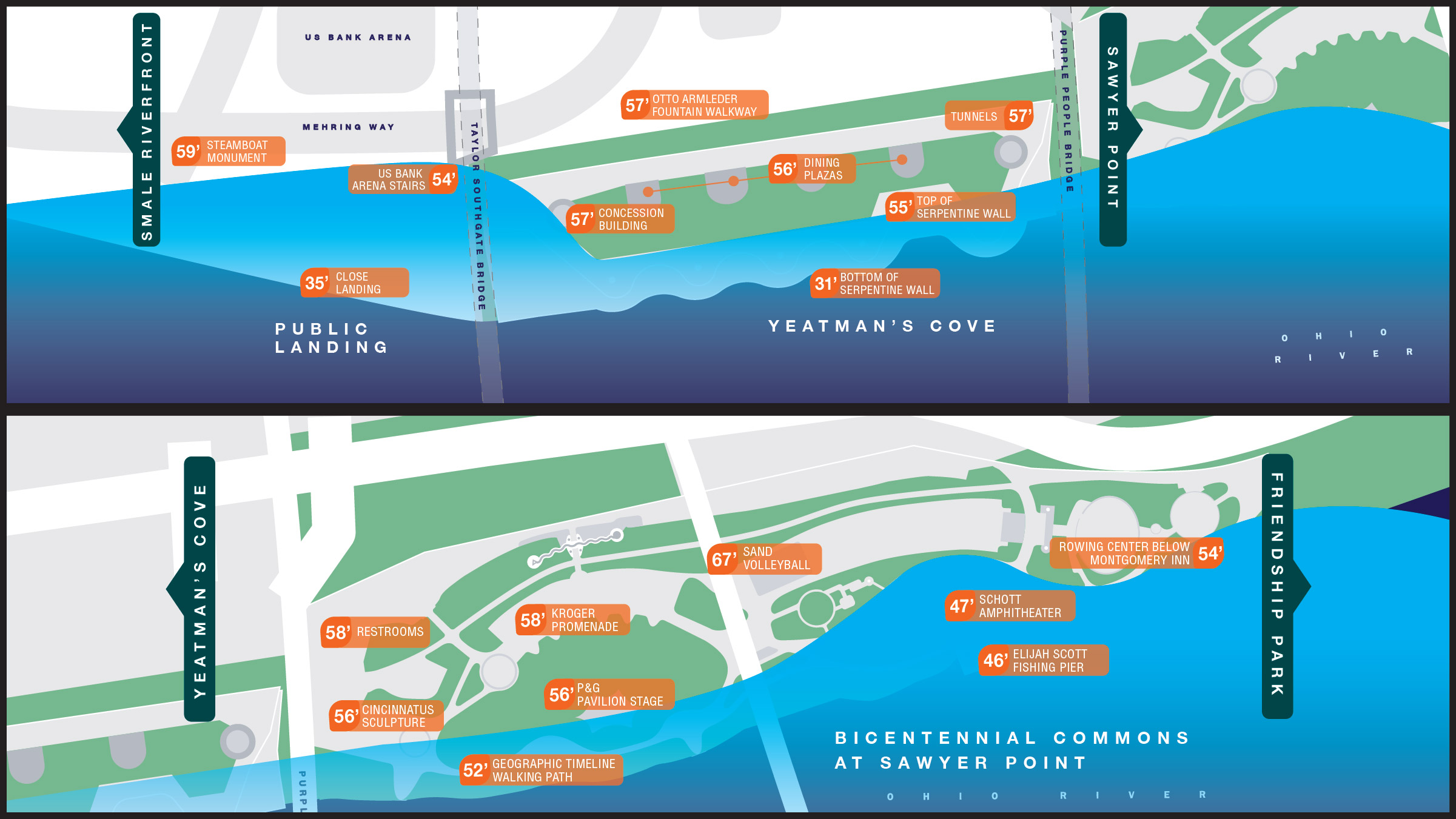
This is not the first time this plan has been put into action. In February 2018 the River crested at 60.53 feet, significantly higher than the normal level of 25.4 feet. This was the highest the River has been since 1997 when the river crested at 64.7 feet. The maps below show the respective flood levels where different features and components of the Riverfront parks are affected.
Remember that flood waters are dangerous and should not be entered. The water can be deeper than it appears, have strong currents and is combined with sewer flows. Don’t attempt to drive through flooded areas or swim in flood water!
As river levels recede, our work will just begin. The Cincinnati Parks team will shift efforts to clean up debris left behind and place the parks back into working order.
FAST FACTS:
- Smale Riverfront Park was built as a series of terraces that accommodate seasonal flooding along the river edge, which includes areas lifted out of the floodplain.
- The P&G go Vibrant Interactive Piano keyboard at Smale was designed to be removed.
- The restrooms under the Roebling Bridge are mobile units which can be moved offsite, bringing a whole new meaning to portable potties.
- Smale Park’s Great Lawn is an expansive area for programs and events and was intentionally left open to prevent park features from being destroyed during a flood.
- The serpentine wall at Yeatman’s Cove is a “hard-edge”, constructed to protect and stabilize the bank.
- Bollard lighting along the Riverwalk are removable by design and one of the first items pulled during flooding.